


bligny sur ouche

LUCIE2016
User
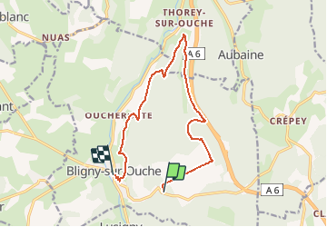

Length
12.5 km

Max alt
524 m

Uphill gradient
205 m
Km-Effort
15.7 km

Min alt
360 m

Downhill gradient
347 m
Boucle
No
Creation date :
2019-05-06 17:03:07.116
Updated on :
2019-05-06 17:03:07.116
--
Difficulty : Unknown

FREE GPS app for hiking
 SityTrail
IGN / Geographical institutes
SityTrail Plus
The world is yours!
About
Trail Walking of 12.5 km to be discovered at Bourgogne-Franche-Comté, Côte-d'Or, Bligny-sur-Ouche. This trail is proposed by LUCIE2016.
Positioning
Country:
France
Region :
Bourgogne-Franche-Comté
Department/Province :
Côte-d'Or
Municipality :
Bligny-sur-Ouche
Location:
Unknown
Start:(Dec)
Start:(UTM)
628140 ; 5217797 (31T) N.
Comments