


FRONTIERE VRAI

UDGI54
User
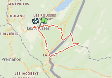

Length
15.3 km

Max alt
1321 m

Uphill gradient
353 m
Km-Effort
20 km

Min alt
1072 m

Downhill gradient
352 m
Boucle
Yes
Creation date :
2019-05-06 17:09:58.215
Updated on :
2019-05-06 17:09:58.215
5h00
Difficulty : Unknown

FREE GPS app for hiking
 SityTrail
IGN / Geographical institutes
SityTrail Plus
The world is yours!
About
Trail Walking of 15.3 km to be discovered at Bourgogne-Franche-Comté, Jura, Les Rousses. This trail is proposed by UDGI54.
Positioning
Country:
France
Region :
Bourgogne-Franche-Comté
Department/Province :
Jura
Municipality :
Les Rousses
Location:
Unknown
Start:(Dec)
Start:(UTM)
274518 ; 5152211 (32T) N.
Comments