


MT ROND VRAI

UDGI54
User
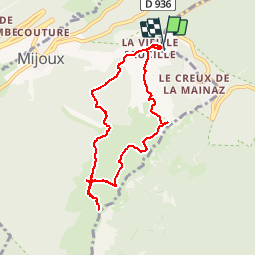

Length
8 km

Max alt
1583 m

Uphill gradient
372 m
Km-Effort
12.9 km

Min alt
1317 m

Downhill gradient
369 m
Boucle
Yes
Creation date :
2019-05-06 17:10:30.977
Updated on :
2019-05-06 17:10:30.977
2h39
Difficulty : Unknown

FREE GPS app for hiking
 SityTrail
IGN / Geographical institutes
SityTrail Plus
The world is yours!
About
Trail Walking of 8 km to be discovered at Auvergne-Rhône-Alpes, Ain, Gex. This trail is proposed by UDGI54.
Positioning
Country:
France
Region :
Auvergne-Rhône-Alpes
Department/Province :
Ain
Municipality :
Gex
Location:
Unknown
Start:(Dec)
Start:(UTM)
270579 ; 5139190 (32T) N.
Comments