


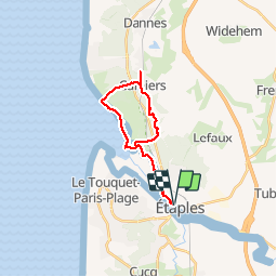
la canche camier

doudet
User

Length
18.8 km

Max alt
68 m

Uphill gradient
142 m
Km-Effort
21 km

Min alt
0 m

Downhill gradient
143 m
Boucle
Yes
Creation date :
2019-05-06 17:46:41.154
Updated on :
2019-05-06 17:46:41.154
5h27
Difficulty : Medium

FREE GPS app for hiking
 SityTrail
IGN / Geographical institutes
SityTrail Plus
The world is yours!
About
Trail Walking of 18.8 km to be discovered at Hauts-de-France, Pas-de-Calais, Étaples. This trail is proposed by doudet.
Positioning
Country:
France
Region :
Hauts-de-France
Department/Province :
Pas-de-Calais
Municipality :
Étaples
Location:
Unknown
Start:(Dec)
Start:(UTM)
403188 ; 5596793 (31U) N.
Comments