


Tournon les 2 rives

cousam
User
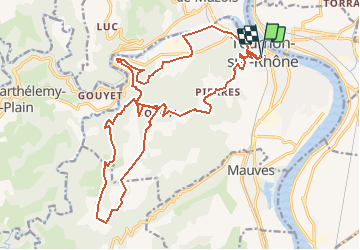

Length
24 km

Max alt
513 m

Uphill gradient
880 m
Km-Effort
36 km

Min alt
118 m

Downhill gradient
882 m
Boucle
Yes
Creation date :
2019-05-06 22:42:06.967
Updated on :
2019-05-06 22:42:06.967
7h24
Difficulty : Medium

FREE GPS app for hiking
 SityTrail
IGN / Geographical institutes
SityTrail Plus
The world is yours!
About
Trail Walking of 24 km to be discovered at Auvergne-Rhône-Alpes, Ardèche, Tournon-sur-Rhône. This trail is proposed by cousam.
Description
Tournon les 2 rives
Positioning
Country:
France
Region :
Auvergne-Rhône-Alpes
Department/Province :
Ardèche
Municipality :
Tournon-sur-Rhône
Location:
Unknown
Start:(Dec)
Start:(UTM)
644244 ; 4991970 (31T) N.
Comments