


18 MARS 2018

FLOCON
User
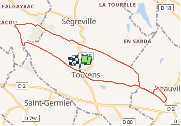

Length
10.6 km

Max alt
288 m

Uphill gradient
139 m
Km-Effort
12.4 km

Min alt
204 m

Downhill gradient
138 m
Boucle
Yes
Creation date :
2019-05-06 22:44:52.175
Updated on :
2019-05-06 22:44:52.175
2h24
Difficulty : Medium

FREE GPS app for hiking
 SityTrail
IGN / Geographical institutes
SityTrail Plus
The world is yours!
About
Trail Walking of 10.6 km to be discovered at Occitania, Haute-Garonne, Toutens. This trail is proposed by FLOCON.
Description
TOUTENS
Positioning
Country:
France
Region :
Occitania
Department/Province :
Haute-Garonne
Municipality :
Toutens
Location:
Unknown
Start:(Dec)
Start:(UTM)
398342 ; 4814650 (31T) N.
Comments