


Coye la Foret

Francine
User

Length
11.6 km

Max alt
134 m

Uphill gradient
179 m
Km-Effort
14 km

Min alt
45 m

Downhill gradient
179 m
Boucle
Yes
Creation date :
2019-05-06 22:58:25.954
Updated on :
2019-05-06 22:58:25.954
3h02
Difficulty : Medium

FREE GPS app for hiking
 SityTrail
IGN / Geographical institutes
SityTrail Plus
The world is yours!
About
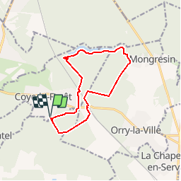
Trail Walking of 11.6 km to be discovered at Hauts-de-France, Oise, Coye-la-Forêt. This trail is proposed by Francine.
Description
Coye la Forêt
Positioning
Country:
France
Region :
Hauts-de-France
Department/Province :
Oise
Municipality :
Coye-la-Forêt
Location:
Unknown
Start:(Dec)
Start:(UTM)
461423 ; 5442733 (31U) N.
Comments