Trail Walking Guer - Boucle du Dran - Guer - Photo

Boucle du Dran - Guer

 tracegps
tracegps

User

© OpenStreetMap contributors
Length
Length
11.2 km
Max alt
Max alt
114 m
Uphill gradient
Uphill gradient
162 m
Km-Effort
Km-Effort  
13.4 km
Min alt
Min alt
27 m
Downhill gradient
Downhill gradient
162 m
Boucle
Boucle
Yes
Creation date :
2014-12-10 00:00:00.0
Updated on :
2014-12-10 00:00:00.0

(0 Reviews)

Walking
Walking
3h00
Difficulty : Medium

Scan this QR Code to open this trail in the SityTrail application

FREE GPS app for hiking

Logo SityTrail SityTrail

IGN / Geographical institutes

Download SityTrail from the App Store Download SityTrail from Google Play

Logo SityTrail SityTrail World

The world is yours!

Download SityTrail from the App Store Download SityTrail from Google Play Download SityTrail on Huawei AppGallery

About

Trail Walking of 11.2 km to be discovered at Brittany, Morbihan, Guer. This trail is proposed by tracegps.

Description

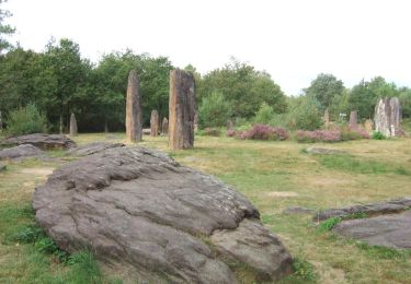
Circuit proposé par le Pays de l’Oust à Brocéliande. Au gré de ce parcours vous découvrirez la nature préservée de ces lieux, le manoir de Couedor, le Prieuré Saint Etiennne, la pierre tremblante, l'if millénaire sans oublier le centre ville de Guer. Rendez-vous sur le site internet du Pays de l’Oust à Brocéliande pour télécharger la fiche pratique du circuit et découvrir le patrimoine à voir en chemin.

Elevation profile

Positioning

Country:
France
Region :
Brittany
Department/Province :
Morbihan
Municipality :
Guer
Location:
Unknown
Start:(UTM)
565795 ; 5306030 (30T) N.

Trails nearby

Trail On foot Monteneuf - Boucle de l'étang de Quéhéon - Photo
On foot
PRO

On foot

Easy
Monteneuf, Brittany, Morbihan, France
4.6 km | 5.3 km-effort
1h 12min
Yes
Trail On foot Monteneuf - Boucle de la pièce couverte - Photo
On foot
PRO

On foot

Easy
Monteneuf, Brittany, Morbihan, France
4.1 km | 5.1 km-effort
1h 8min
Yes
Trail Walking Guer - essai - Photo
Walking
altijovima

Walking

Medium
Guer, Brittany, Morbihan, France
8.6 km | 10.4 km-effort
Unknown
No
Trail Mountain bike Comblessac -  La rando des coteaux de l'Aff - Comblessac - Photo
Mountain bike
tracegps

Mountain bike

Difficult
Comblessac, Brittany, Ille-et-Vilaine, France
32 km | 38 km-effort
2h 30min
Yes
Trail On foot Loutehel - La vallée de ropenard - Photo
On foot
jackpot

On foot

Easy
Loutehel, Brittany, Ille-et-Vilaine, France
11.9 km | 14.2 km-effort
3h 13min
Yes
Trail On foot Monteneuf - Boucle des Bordoués - Photo
On foot
PRO

On foot

Easy
Monteneuf, Brittany, Morbihan, France
3.1 km | 3.6 km-effort
49min
Yes
Trail Walking Loutehel - Le louetel - Photo
Walking
Ameligue

Walking

Very easy
Loutehel, Brittany, Ille-et-Vilaine, France
9.3 km | 10.8 km-effort
2h 32min
Yes
Trail Walking Monteneuf - Boucle de la voie romaine - Monteneuf - Photo
Walking
tracegps

Walking

Medium
Monteneuf, Brittany, Morbihan, France
7.2 km | 8.7 km-effort
2h 0min
Yes
Trail Walking Monteneuf - monteneuf - Photo
Walking
Yolande Olivier

Walking

Very difficult
Monteneuf, Brittany, Morbihan, France
28 km | 34 km-effort
6h 19min
Yes


Close
My subscriptions