Trail Walking Taupont - Circuit du Ninian - Taupont - Photo

Circuit du Ninian - Taupont

 tracegps
tracegps

User

© OpenStreetMap contributors
Length
Length
9.9 km
Max alt
Max alt
82 m
Uphill gradient
Uphill gradient
121 m
Km-Effort
Km-Effort  
11.6 km
Min alt
Min alt
31 m
Downhill gradient
Downhill gradient
120 m
Boucle
Boucle
Yes
Creation date :
2014-12-10 00:00:00.0
Updated on :
2014-12-10 00:00:00.0

(0 Reviews)

Walking
Walking
2h30
Difficulty : Medium

Scan this QR Code to open this trail in the SityTrail application

FREE GPS app for hiking

Logo SityTrail SityTrail

IGN / Geographical institutes

Download SityTrail from the App Store Download SityTrail from Google Play

Logo SityTrail SityTrail World

The world is yours!

Download SityTrail from the App Store Download SityTrail from Google Play Download SityTrail on Huawei AppGallery

About

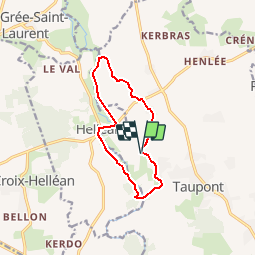
Trail Walking of 9.9 km to be discovered at Brittany, Morbihan, Taupont. This trail is proposed by tracegps.

Description

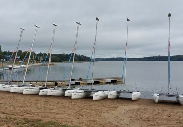
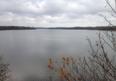
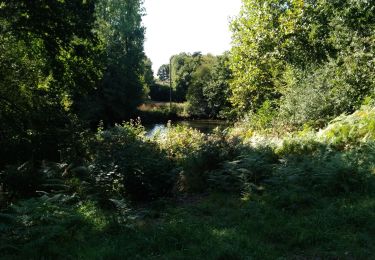
Point de départ : site de Beaumont (commune de Taupont) - Coordonnées GPS : 02°27’35’’O / 47°57’54’’N - Distance : 10 km - 2 h 30 A voir en chemin: 1. Le site de Beaumont : classé espace naturel sensible, ce site est géré par le Conseil général du Morbihan. En relation avec les collectivités locales, le département veille notamment à l’aménagement, l’entretien du site ainsi qu’à la préservation des habitats naturels. Un parcours handi pêche est en cours d’aménagement. 2. Jonction entre les cours d’eau du Ninian et du Léverin : d’une longueur de 52 km, le Ninian prend sa source dans le Mené, du côté de Laurenan dans les Côtes d’Armor tandis que le Léverin prend sa source du côté de Ménéac dans le Morbihan. Les 2 cours d’eau se retrouve à Taupont et entre Josselin et Ploërmel, ils retrouvent l’Yvel pour aller se jeter dans l’Oust à Montertelot. Ces deux cours d’eau offrent un habitat favorable à la truite. Contact: Office de tourisme de Ploërmel « Terres de légendes ». Tel : 02 97 74 02 70 - Email : accueil (at) tourisme-ploermel.com

Elevation profile

Positioning

Country:
France
Region :
Brittany
Department/Province :
Morbihan
Municipality :
Taupont
Location:
Unknown
Start:(UTM)
540320 ; 5312544 (30T) N.

Trails nearby

Trail Walking Taupont - GR_37_CG_41_Taupont_Josselin_20221015 - Photo
Walking
patrickdanilo

Walking

Very difficult
Taupont, Brittany, Morbihan, France
21 km | 25 km-effort
5h 18min
No
Trail Walking Ploërmel - LAC AU DUC (56) - Photo
Walking
0010Jacem.1957

Walking

Very easy
Ploërmel, Brittany, Morbihan, France
14.6 km | 16.1 km-effort
2h 42min
Yes
Trail Walking Ploërmel - la ville bouquet - Photo
Walking
motardfou.dgs

Walking

Easy
Ploërmel, Brittany, Morbihan, France
10.1 km | 11.8 km-effort
2h 27min
No
Trail Other activity Taupont - taupins - Photo
Other activity
bourdet

Other activity

Very easy
Taupont, Brittany, Morbihan, France
21 km | 24 km-effort
5h 59min
No
Trail Nordic walking Taupont - 2018-09-30 TAUPONT CHEMIN DES CHAPELLES - Photo
Nordic walking
rousseau.mich

Nordic walking

Very easy
Taupont, Brittany, Morbihan, France
11.5 km | 13 km-effort
2h 36min
Yes
Trail Walking Guillac - lA croix des AnglaiS - Photo
Walking
shadow

Walking

Easy
Guillac, Brittany, Morbihan, France
6.4 km | 7.6 km-effort
1h 40min
Yes
Trail Nordic walking Ploërmel - LAC AU DUC. 25 06 13 - Photo
Nordic walking
rousseau.mich

Nordic walking

Very easy
Ploërmel, Brittany, Morbihan, France
7.9 km | 9.1 km-effort
1h 28min
Yes
Trail Motor Ploërmel - ballade 2 jours moto dept 22. 22 23 juin 13 - Photo
Motor
rousseau.mich

Motor

Very easy
Ploërmel, Brittany, Morbihan, France
495 km | 574 km-effort
35h 2min
No
Trail Walking Ploërmel - Le tour du lac au Duc - Ploërmel - Photo
Walking
tracegps

Walking

Medium
Ploërmel, Brittany, Morbihan, France
13.7 km | 15.2 km-effort
4h 0min
Yes


Close
My subscriptions