


25 MARS 2019

FLOCON
User
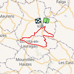

Length
10.4 km

Max alt
297 m

Uphill gradient
196 m
Km-Effort
13 km

Min alt
214 m

Downhill gradient
197 m
Boucle
Yes
Creation date :
2019-05-06 23:16:27.381
Updated on :
2019-05-06 23:16:27.381
2h32
Difficulty : Medium

FREE GPS app for hiking
 SityTrail
IGN / Geographical institutes
SityTrail Plus
The world is yours!
About
Trail Walking of 10.4 km to be discovered at Occitania, Haute-Garonne, Vaux. This trail is proposed by FLOCON.
Description
LE VAUX
Positioning
Country:
France
Region :
Occitania
Department/Province :
Haute-Garonne
Municipality :
Vaux
Location:
Unknown
Start:(Dec)
Start:(UTM)
405948 ; 4812126 (31T) N.
Comments