


03 - Le Tour-col de Balme-lac de Catone-Aiguillette des Posettes

geranimo
User
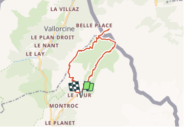

Length
13.9 km

Max alt
2234 m

Uphill gradient
986 m
Km-Effort
27 km

Min alt
1469 m

Downhill gradient
988 m
Boucle
Yes
Creation date :
2019-05-06 23:20:05.164
Updated on :
2022-01-24 18:24:16.238
3h41
Difficulty : Difficult

FREE GPS app for hiking
 SityTrail
IGN / Geographical institutes
SityTrail Plus
The world is yours!
About
Trail Walking of 13.9 km to be discovered at Auvergne-Rhône-Alpes, Upper Savoy, Chamonix-Mont-Blanc. This trail is proposed by geranimo.
Positioning
Country:
France
Region :
Auvergne-Rhône-Alpes
Department/Province :
Upper Savoy
Municipality :
Chamonix-Mont-Blanc
Location:
Unknown
Start:(Dec)
Start:(UTM)
341087 ; 5096248 (32T) N.
Comments