


hatton fosse fournier hatton

ochelen
User
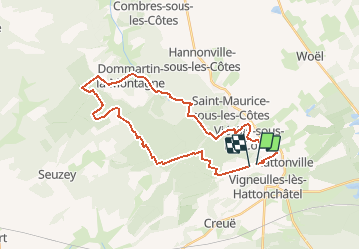

Length
30 km

Max alt
415 m

Uphill gradient
574 m
Km-Effort
37 km

Min alt
247 m

Downhill gradient
567 m
Boucle
No
Creation date :
2019-05-06 23:22:21.674
Updated on :
2019-05-06 23:22:21.674
1h35
Difficulty : Unknown

FREE GPS app for hiking
 SityTrail
IGN / Geographical institutes
SityTrail Plus
The world is yours!
About
Trail Equestrian of 30 km to be discovered at Grand Est, Meuse, Vigneulles-lès-Hattonchâtel. This trail is proposed by ochelen.
Positioning
Country:
France
Region :
Grand Est
Department/Province :
Meuse
Municipality :
Vigneulles-lès-Hattonchâtel
Location:
Hattonchâtel
Start:(Dec)
Start:(UTM)
697181 ; 5429942 (31U) N.
Comments