


voie verte

guyzinz
User

Length
12.2 km

Max alt
171 m

Uphill gradient
97 m
Km-Effort
13.5 km

Min alt
137 m

Downhill gradient
98 m
Boucle
Yes
Creation date :
2019-06-07 09:38:45.556
Updated on :
2019-06-07 09:38:45.612
2h09
Difficulty : Unknown

FREE GPS app for hiking
 SityTrail
IGN / Geographical institutes
SityTrail Plus
The world is yours!
About
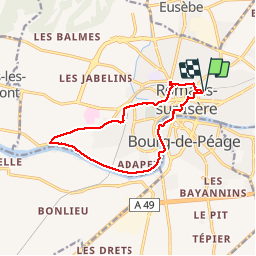
Trail Walking of 12.2 km to be discovered at Auvergne-Rhône-Alpes, Drôme, Romans-sur-Isère. This trail is proposed by guyzinz.
Positioning
Country:
France
Region :
Auvergne-Rhône-Alpes
Department/Province :
Drôme
Municipality :
Romans-sur-Isère
Location:
Unknown
Start:(Dec)
Start:(UTM)
662174 ; 4990322 (31T) N.
Comments