


Brec d'Ilonse

franquen
User
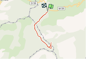

Length
7 km

Max alt
1726 m

Uphill gradient
353 m
Km-Effort
11.7 km

Min alt
1404 m

Downhill gradient
351 m
Boucle
Yes
Creation date :
2019-05-06 23:34:46.221
Updated on :
2019-05-06 23:34:46.221
2h50
Difficulty : Easy

FREE GPS app for hiking
 SityTrail
IGN / Geographical institutes
SityTrail Plus
The world is yours!
About
Trail Walking of 7 km to be discovered at Provence-Alpes-Côte d'Azur, Maritime Alps, Ilonse. This trail is proposed by franquen.
Description
Petite rando facile avec une très jolie vue du Brec à 360°.
traversr Ilonse et prendre la route de Pierlas sur 4km jusqu'au col de la Sinne.
Positioning
Country:
France
Region :
Provence-Alpes-Côte d'Azur
Department/Province :
Maritime Alps
Municipality :
Ilonse
Location:
Unknown
Start:(Dec)
Start:(UTM)
345174 ; 4876439 (32T) N.
Comments