


Ski de Rando Cime de la Bonette Col de l Alpe Crêtes de Rougne

trailer.nono
User
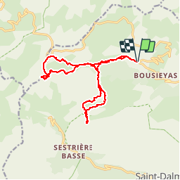

Length
17.1 km

Max alt
2845 m

Uphill gradient
1332 m
Km-Effort
35 km

Min alt
1988 m

Downhill gradient
1333 m
Boucle
Yes
Creation date :
2019-05-06 23:46:18.157
Updated on :
2019-05-06 23:46:18.157
4h48
Difficulty : Medium

FREE GPS app for hiking
 SityTrail
IGN / Geographical institutes
SityTrail Plus
The world is yours!
About
Trail Other activity of 17.1 km to be discovered at Provence-Alpes-Côte d'Azur, Maritime Alps, Saint-Dalmas-le-Selvage. This trail is proposed by trailer.nono.
Positioning
Country:
France
Region :
Provence-Alpes-Côte d'Azur
Department/Province :
Maritime Alps
Municipality :
Saint-Dalmas-le-Selvage
Location:
Unknown
Start:(Dec)
Start:(UTM)
328780 ; 4910400 (32T) N.
Comments