


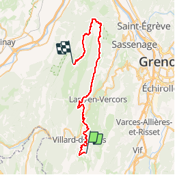
Zevtt - Villard de Lans-Autrans

kipoura
User

Length
45 km

Max alt
1709 m

Uphill gradient
1262 m
Km-Effort
62 km

Min alt
980 m

Downhill gradient
1466 m
Boucle
No
Creation date :
2019-05-03 17:11:31.903
Updated on :
2019-05-03 17:11:32.016
4h00
Difficulty : Difficult

FREE GPS app for hiking
 SityTrail
IGN / Geographical institutes
SityTrail Plus
The world is yours!
About
Trail Mountain bike of 45 km to be discovered at Auvergne-Rhône-Alpes, Isère, Villard-de-Lans. This trail is proposed by kipoura.
Description
Premiére journée d'une boucle VTT au départ de Villard de Lans en direction d'Autrans. http://zevtt.free.fr
Positioning
Country:
France
Region :
Auvergne-Rhône-Alpes
Department/Province :
Isère
Municipality :
Villard-de-Lans
Location:
Unknown
Start:(Dec)
Start:(UTM)
702047 ; 4991852 (31T) N.
Comments