


baisy thy

ochelen
User
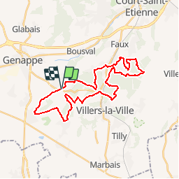

Length
29 km

Max alt
164 m

Uphill gradient
526 m
Km-Effort
36 km

Min alt
78 m

Downhill gradient
527 m
Boucle
Yes
Creation date :
2019-05-06 23:54:24.69
Updated on :
2019-05-06 23:54:24.69
4h31
Difficulty : Unknown

FREE GPS app for hiking
 SityTrail
IGN / Geographical institutes
SityTrail Plus
The world is yours!
About
Trail Equestrian of 29 km to be discovered at Wallonia, Walloon Brabant, Genappe. This trail is proposed by ochelen.
Positioning
Country:
Belgium
Region :
Wallonia
Department/Province :
Walloon Brabant
Municipality :
Genappe
Location:
Baisy-Thy
Start:(Dec)
Start:(UTM)
605469 ; 5605566 (31U) N.
Comments