


grosiboutjpb

jpb1309
User
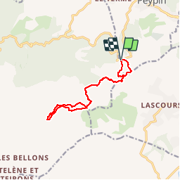

Length
12.7 km

Max alt
689 m

Uphill gradient
442 m
Km-Effort
18.6 km

Min alt
420 m

Downhill gradient
436 m
Boucle
Yes
Creation date :
2019-05-07 00:03:37.94
Updated on :
2019-05-07 00:03:37.94
4h57
Difficulty : Unknown

FREE GPS app for hiking
 SityTrail
IGN / Geographical institutes
SityTrail Plus
The world is yours!
About
Trail Other activity of 12.7 km to be discovered at Provence-Alpes-Côte d'Azur, Bouches-du-Rhône, Peypin. This trail is proposed by jpb1309.
Positioning
Country:
France
Region :
Provence-Alpes-Côte d'Azur
Department/Province :
Bouches-du-Rhône
Municipality :
Peypin
Location:
Unknown
Start:(Dec)
Start:(UTM)
707666 ; 4804225 (31T) N.
Comments