


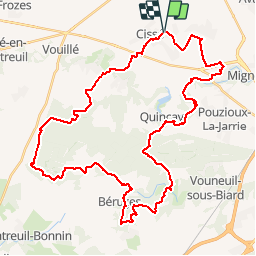
Zevtt - Cissé 46 km

kipoura
User

Length
46 km

Max alt
164 m

Uphill gradient
496 m
Km-Effort
53 km

Min alt
82 m

Downhill gradient
495 m
Boucle
Yes
Creation date :
2019-05-03 17:11:07.235
Updated on :
2019-05-03 17:11:07.308
2h30
Difficulty : Medium

FREE GPS app for hiking
 SityTrail
IGN / Geographical institutes
SityTrail Plus
The world is yours!
About
Trail Mountain bike of 46 km to be discovered at New Aquitaine, Vienne, Cissé. This trail is proposed by kipoura.
Description
Sortie des plaines de Cissé direction la forêt de Vouillé pour du ludique à gogo .... http:zevtt.free.fr
Positioning
Country:
France
Region :
New Aquitaine
Department/Province :
Vienne
Municipality :
Cissé
Location:
Unknown
Start:(Dec)
Start:(UTM)
288635 ; 5169655 (31T) N.
Comments