


rando du 7 avril 4x4

association
User
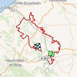

Length
156 km

Max alt
234 m

Uphill gradient
2341 m
Km-Effort
187 km

Min alt
20 m

Downhill gradient
2331 m
Boucle
No
Creation date :
2019-05-07 00:12:44.537
Updated on :
2019-05-07 00:12:44.537
2h21
Difficulty : Unknown

FREE GPS app for hiking
 SityTrail
IGN / Geographical institutes
SityTrail Plus
The world is yours!
About
Trail Other activity of 156 km to be discovered at Normandy, Seine-Maritime, Haudricourt. This trail is proposed by association.
Positioning
Country:
France
Region :
Normandy
Department/Province :
Seine-Maritime
Municipality :
Haudricourt
Location:
Unknown
Start:(Dec)
Start:(UTM)
408779 ; 5511351 (31U) N.
Comments