


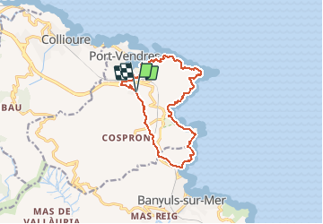
port vendres - bayeuls - aller par les vignobles et retour par le sentier littoral

stef789
User GUIDE

Length
14.6 km

Max alt
102 m

Uphill gradient
430 m
Km-Effort
20 km

Min alt
0 m

Downhill gradient
434 m
Boucle
Yes
Creation date :
2019-05-07 00:20:01.78
Updated on :
2019-05-07 00:20:01.78
5h58
Difficulty : Unknown

FREE GPS app for hiking
 SityTrail
IGN / Geographical institutes
SityTrail Plus
The world is yours!
About
Trail Walking of 14.6 km to be discovered at Occitania, Pyrénées-Orientales, Port-Vendres. This trail is proposed by stef789.
Photos


Positioning
Country:
France
Region :
Occitania
Department/Province :
Pyrénées-Orientales
Municipality :
Port-Vendres
Location:
Unknown
Start:(Dec)
Start:(UTM)
509095 ; 4706415 (31T) N.
Comments