


Zevtt - St Benoît 1

kipoura
User
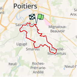

Length
25 km

Max alt
136 m

Uphill gradient
320 m
Km-Effort
29 km

Min alt
73 m

Downhill gradient
322 m
Boucle
Yes
Creation date :
2019-05-03 17:10:54.206
Updated on :
2019-05-03 17:10:55.615
--
Difficulty : Medium

FREE GPS app for hiking
 SityTrail
IGN / Geographical institutes
SityTrail Plus
The world is yours!
About
Trail Mountain bike of 25 km to be discovered at New Aquitaine, Vienne, Saint-Benoît. This trail is proposed by kipoura.
Description
Allez encore un petit tour VTT sur St Benoît, on ne s'en lasse jamais .... http://zevtt.free.fr
Positioning
Country:
France
Region :
New Aquitaine
Department/Province :
Vienne
Municipality :
Saint-Benoît
Location:
Unknown
Start:(Dec)
Start:(UTM)
298122 ; 5158826 (31T) N.
Comments