


Zevtt - Colombiers 2011

kipoura
User
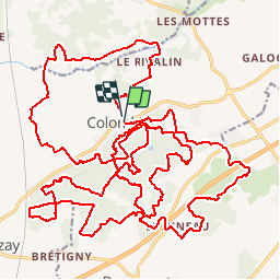

Length
42 km

Max alt
157 m

Uphill gradient
499 m
Km-Effort
49 km

Min alt
57 m

Downhill gradient
519 m
Boucle
Yes
Creation date :
2019-05-03 17:10:52.75
Updated on :
2019-05-03 17:10:52.835
2h30
Difficulty : Medium

FREE GPS app for hiking
 SityTrail
IGN / Geographical institutes
SityTrail Plus
The world is yours!
About
Trail Mountain bike of 42 km to be discovered at New Aquitaine, Vienne, Colombiers. This trail is proposed by kipoura.
Description
Colombiers et sa forêt tout ce qu'il faut pour une sortie VTT réussite .... http://zevtt.free.fr
Positioning
Country:
France
Region :
New Aquitaine
Department/Province :
Vienne
Municipality :
Colombiers
Location:
Unknown
Start:(Dec)
Start:(UTM)
303450 ; 5183046 (31T) N.
Comments