


labbevile mariers

avdem
User
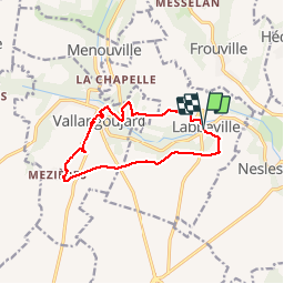

Length
10.8 km

Max alt
111 m

Uphill gradient
146 m
Km-Effort
12.8 km

Min alt
41 m

Downhill gradient
147 m
Boucle
Yes
Creation date :
2019-05-07 00:44:15.293
Updated on :
2019-05-07 00:44:15.293
2h38
Difficulty : Unknown

FREE GPS app for hiking
 SityTrail
IGN / Geographical institutes
SityTrail Plus
The world is yours!
About
Trail Other activity of 10.8 km to be discovered at Ile-de-France, Val-d'Oise, Labbeville. This trail is proposed by avdem.
Photos

Positioning
Country:
France
Region :
Ile-de-France
Department/Province :
Val-d'Oise
Municipality :
Labbeville
Location:
Unknown
Start:(Dec)
Start:(UTM)
437568 ; 5442942 (31U) N.
Comments