aurel

guyzinz
User
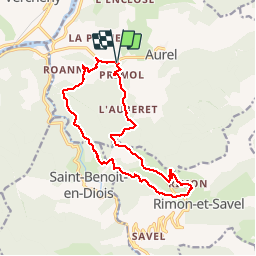

Length
15.8 km

Max alt
1059 m

Uphill gradient
834 m
Km-Effort
27 km

Min alt
326 m

Downhill gradient
834 m
Boucle
Yes
Creation date :
2019-06-07 09:38:43.687
Updated on :
2019-06-07 09:38:43.866
5h29
Difficulty : Unknown

FREE GPS app for hiking
 SityTrail
IGN / Geographical institutes
SityTrail Plus
The world is yours!
About
Trail Walking of 15.8 km to be discovered at Auvergne-Rhône-Alpes, Drôme, Aurel. This trail is proposed by guyzinz.
Positioning
Country:
France
Region :
Auvergne-Rhône-Alpes
Department/Province :
Drôme
Municipality :
Aurel
Location:
Unknown
Start:(Dec)
Start:(UTM)
680911 ; 4951373 (31T) N.
Comments