


Loubressac-Autoire

ZAMBAUX
User
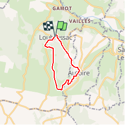

Length
8.7 km

Max alt
386 m

Uphill gradient
302 m
Km-Effort
12.7 km

Min alt
170 m

Downhill gradient
303 m
Boucle
Yes
Creation date :
2019-04-27 09:34:08.768
Updated on :
2019-04-27 09:34:08.8
2h39
Difficulty : Easy

FREE GPS app for hiking
 SityTrail
IGN / Geographical institutes
SityTrail Plus
The world is yours!
About
Trail Walking of 8.7 km to be discovered at Occitania, Lot, Loubressac. This trail is proposed by ZAMBAUX.
Positioning
Country:
France
Region :
Occitania
Department/Province :
Lot
Municipality :
Loubressac
Location:
Unknown
Start:(Dec)
Start:(UTM)
405538 ; 4969387 (31T) N.
Comments