


fleron . chantraine . magnee . fond de foret . fleron

stef789
User GUIDE
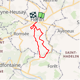

Length
9.3 km

Max alt
268 m

Uphill gradient
226 m
Km-Effort
12.3 km

Min alt
111 m

Downhill gradient
227 m
Boucle
Yes
Creation date :
2019-05-07 01:12:54.26
Updated on :
2019-05-07 01:12:54.26
2h42
Difficulty : Unknown

FREE GPS app for hiking
 SityTrail
IGN / Geographical institutes
SityTrail Plus
The world is yours!
About
Trail Walking of 9.3 km to be discovered at Wallonia, Liège, Fléron. This trail is proposed by stef789.
Photos


Positioning
Country:
Belgium
Region :
Wallonia
Department/Province :
Liège
Municipality :
Fléron
Location:
Fléron
Start:(Dec)
Start:(UTM)
689807 ; 5610396 (31U) N.
Comments