


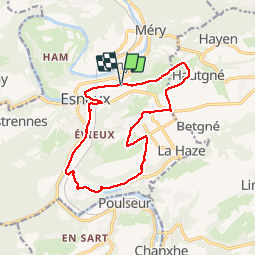
dans la campagne d Esneux

stef789
User GUIDE

Length
12.8 km

Max alt
232 m

Uphill gradient
248 m
Km-Effort
16.1 km

Min alt
85 m

Downhill gradient
253 m
Boucle
Yes
Creation date :
2019-05-07 01:16:19.682
Updated on :
2019-05-07 01:16:19.682
2h55
Difficulty : Unknown

FREE GPS app for hiking
 SityTrail
IGN / Geographical institutes
SityTrail Plus
The world is yours!
About
Trail Walking of 12.8 km to be discovered at Wallonia, Liège, Esneux. This trail is proposed by stef789.
Description
cimetiere esneux . avionpuits . hautgné . fontin . montfort. souverain pré. esneux . cimetière
Photos


Positioning
Country:
Belgium
Region :
Wallonia
Department/Province :
Liège
Municipality :
Esneux
Location:
Esneux
Start:(Dec)
Start:(UTM)
682969 ; 5601360 (31U) N.
Comments
Belle randonnée à Esneux. Merci !