


Foret de St Hubert

micheldutilleul
User
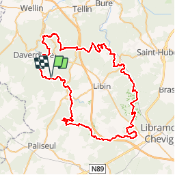

Length
78 km

Max alt
498 m

Uphill gradient
1772 m
Km-Effort
102 km

Min alt
215 m

Downhill gradient
1772 m
Boucle
Yes
Creation date :
2019-05-07 01:17:58.486
Updated on :
2019-05-07 01:17:58.486
21h44
Difficulty : Medium

FREE GPS app for hiking
 SityTrail
IGN / Geographical institutes
SityTrail Plus
The world is yours!
About
Trail Walking of 78 km to be discovered at Wallonia, Luxembourg, Libin. This trail is proposed by micheldutilleul.

Positioning
Country:
Belgium
Region :
Wallonia
Department/Province :
Luxembourg
Municipality :
Libin
Location:
Redu
Start:(Dec)
Start:(UTM)
654407 ; 5539987 (31U) N.
Comments