


Rocamadour_canyon de l'Alzou_11kms

ZAMBAUX
User
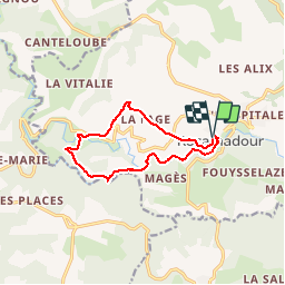

Length
10.8 km

Max alt
269 m

Uphill gradient
353 m
Km-Effort
15.5 km

Min alt
114 m

Downhill gradient
350 m
Boucle
Yes
Creation date :
2019-04-27 09:34:06.842
Updated on :
2019-04-27 09:34:06.97
3h15
Difficulty : Medium

FREE GPS app for hiking
 SityTrail
IGN / Geographical institutes
SityTrail Plus
The world is yours!
About
Trail Walking of 10.8 km to be discovered at Occitania, Lot, Rocamadour. This trail is proposed by ZAMBAUX.


Positioning
Country:
France
Region :
Occitania
Department/Province :
Lot
Municipality :
Rocamadour
Location:
Unknown
Start:(Dec)
Start:(UTM)
390548 ; 4961649 (31T) N.
Comments