


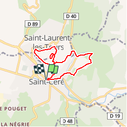
St Céré_6kms

ZAMBAUX
User

Length
6.2 km

Max alt
304 m

Uphill gradient
247 m
Km-Effort
9.5 km

Min alt
151 m

Downhill gradient
247 m
Boucle
Yes
Creation date :
2019-04-27 09:34:04.183
Updated on :
2019-04-27 09:34:04.295
1h58
Difficulty : Easy

FREE GPS app for hiking
 SityTrail
IGN / Geographical institutes
SityTrail Plus
The world is yours!
About
Trail Walking of 6.2 km to be discovered at Occitania, Lot, Saint-Céré. This trail is proposed by ZAMBAUX.


Positioning
Country:
France
Region :
Occitania
Department/Province :
Lot
Municipality :
Saint-Céré
Location:
Unknown
Start:(Dec)
Start:(UTM)
412487 ; 4967887 (31T) N.
Comments