


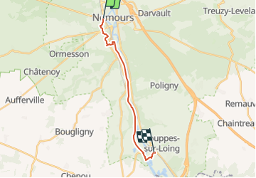
*De Nemours à Souppes-sur-Loing le long du canal

jpcccb
User

Length
13.9 km

Max alt
104 m

Uphill gradient
124 m
Km-Effort
15.6 km

Min alt
60 m

Downhill gradient
119 m
Boucle
No
Creation date :
2019-05-07 01:28:19.288
Updated on :
2023-05-12 14:22:29.785
3h32
Difficulty : Difficult

FREE GPS app for hiking
 SityTrail
IGN / Geographical institutes
SityTrail Plus
The world is yours!
About
Trail Walking of 13.9 km to be discovered at Ile-de-France, Seine-et-Marne, Saint-Pierre-lès-Nemours. This trail is proposed by jpcccb.
Points of interest


Positioning
Country:
France
Region :
Ile-de-France
Department/Province :
Seine-et-Marne
Municipality :
Saint-Pierre-lès-Nemours
Location:
Unknown
Start:(Dec)
Start:(UTM)
476673 ; 5346121 (31U) N.
Comments