


Frontières2019_6

fra_depoorter
User
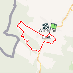

Length
5.3 km

Max alt
335 m

Uphill gradient
134 m
Km-Effort
7.1 km

Min alt
258 m

Downhill gradient
136 m
Boucle
Yes
Creation date :
2019-05-07 01:39:26.039
Updated on :
2019-05-11 17:36:25.276
1h21
Difficulty : Easy

FREE GPS app for hiking
 SityTrail
IGN / Geographical institutes
SityTrail Plus
The world is yours!
About
Trail Walking of 5.3 km to be discovered at Wallonia, Namur, Beauraing. This trail is proposed by fra_depoorter.
Description
Marche FFBMP au départ de Winenne les 6 et 7 juillet 2019
Positioning
Country:
Belgium
Region :
Wallonia
Department/Province :
Namur
Municipality :
Beauraing
Location:
Winenne
Start:(Dec)
Start:(UTM)
635479 ; 5551130 (31U) N.
Comments