


Zevtt - Aslonnes 2011

kipoura
User
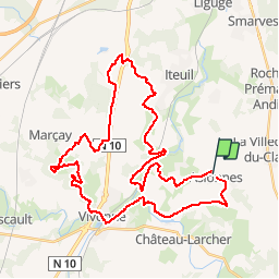

Length
43 km

Max alt
149 m

Uphill gradient
476 m
Km-Effort
49 km

Min alt
84 m

Downhill gradient
475 m
Boucle
No
Creation date :
2019-05-03 17:10:44.873
Updated on :
2019-05-03 17:10:44.941
2h00
Difficulty : Easy

FREE GPS app for hiking
 SityTrail
IGN / Geographical institutes
SityTrail Plus
The world is yours!
About
Trail Mountain bike of 43 km to be discovered at New Aquitaine, Vienne, Aslonnes. This trail is proposed by kipoura.
Description
Sur la race de la randonnée VTT d'Aslonnes 2011 .... http://zevtt.free.fr
Positioning
Country:
France
Region :
New Aquitaine
Department/Province :
Vienne
Municipality :
Aslonnes
Location:
Unknown
Start:(Dec)
Start:(UTM)
295114 ; 5146970 (31T) N.
Comments