


aulas

labarone
User
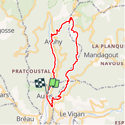

Length
14.8 km

Max alt
931 m

Uphill gradient
643 m
Km-Effort
23 km

Min alt
340 m

Downhill gradient
644 m
Boucle
Yes
Creation date :
2019-05-07 02:04:24.372
Updated on :
2019-05-07 02:04:24.372
4h43
Difficulty : Easy

FREE GPS app for hiking
 SityTrail
IGN / Geographical institutes
SityTrail Plus
The world is yours!
About
Trail Walking of 14.8 km to be discovered at Occitania, Gard, Aulas. This trail is proposed by labarone.
Description
Arsel 25/09/18 rando cool
Positioning
Country:
France
Region :
Occitania
Department/Province :
Gard
Municipality :
Aulas
Location:
Unknown
Start:(Dec)
Start:(UTM)
547178 ; 4872209 (31T) N.
Comments