


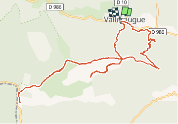
de valleraugue à la tombe de André chansom le 24-7-18

labarone
User


5h19
Difficulty : Difficult

FREE GPS app for hiking
 SityTrail
IGN / Geographical institutes
SityTrail Plus
The world is yours!
About
Trail Walking of 16.9 km to be discovered at Occitania, Gard, Val-d'Aigoual. This trail is proposed by labarone.
Description
Avec Alphonse et kiki À ne pas faire par forte chaleur
Attention erreur de route 2fois
Eviter de faire les 2 derniers kms de descente très pentue et caillouteux, refaire plutôt le chemin inverse du départ par labecede
Positioning
Comments