


04022018 â modifier

ThierryJ01
User
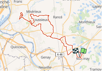

Length
47 km

Max alt
313 m

Uphill gradient
456 m
Km-Effort
53 km

Min alt
195 m

Downhill gradient
456 m
Boucle
Yes
Creation date :
2019-05-07 02:35:23.913
Updated on :
2021-03-29 20:22:55.159
3h31
Difficulty : Unknown

FREE GPS app for hiking
 SityTrail
IGN / Geographical institutes
SityTrail Plus
The world is yours!
About
Trail Mountain bike of 47 km to be discovered at Auvergne-Rhône-Alpes, Ain, Mionnay. This trail is proposed by ThierryJ01.
Positioning
Country:
France
Region :
Auvergne-Rhône-Alpes
Department/Province :
Ain
Municipality :
Mionnay
Location:
Unknown
Start:(Dec)
Start:(UTM)
649156 ; 5084441 (31T) N.
Comments