


VTT st Christophe

phiphidechagny
User

Length
37 km

Max alt
514 m

Uphill gradient
588 m
Km-Effort
45 km

Min alt
204 m

Downhill gradient
587 m
Boucle
Yes
Creation date :
2019-05-07 02:45:46.766
Updated on :
2019-05-07 02:45:46.766
3h21
Difficulty : Medium

FREE GPS app for hiking
 SityTrail
IGN / Geographical institutes
SityTrail Plus
The world is yours!
About
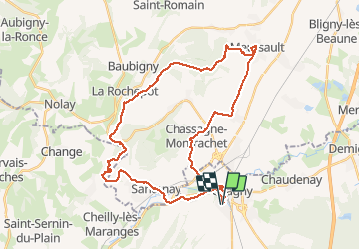
Trail Mountain bike of 37 km to be discovered at Bourgogne-Franche-Comté, Saône-et-Loire, Chagny. This trail is proposed by phiphidechagny.
Positioning
Country:
France
Region :
Bourgogne-Franche-Comté
Department/Province :
Saône-et-Loire
Municipality :
Chagny
Location:
Unknown
Start:(Dec)
Start:(UTM)
632931 ; 5196018 (31T) N.
Comments