


Les Habitations troglodytes de Blaincourt les Précy

Pousscailleux
User
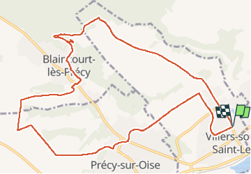

Length
12.9 km

Max alt
119 m

Uphill gradient
186 m
Km-Effort
15.4 km

Min alt
35 m

Downhill gradient
186 m
Boucle
Yes
Creation date :
2014-12-10 00:00:00.0
Updated on :
2022-11-28 14:00:43.917
2h45
Difficulty : Easy

FREE GPS app for hiking
 SityTrail
IGN / Geographical institutes
SityTrail Plus
The world is yours!
About
Trail Walking of 12.9 km to be discovered at Hauts-de-France, Oise, Villers-sous-Saint-Leu. This trail is proposed by Pousscailleux.
Description
Départ du parking de l'église de Villers sous Saint Leu vers le nord ouest.


Positioning
Country:
France
Region :
Hauts-de-France
Department/Province :
Oise
Municipality :
Villers-sous-Saint-Leu
Location:
Unknown
Start:(Dec)
Start:(UTM)
456206 ; 5451279 (31U) N.
Comments