


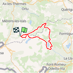
TOUR DES PERICS

UDGI54
User

Length
48 km

Max alt
2587 m

Uphill gradient
2390 m
Km-Effort
80 km

Min alt
1886 m

Downhill gradient
2390 m
Boucle
Yes
Creation date :
2019-05-07 03:01:53.388
Updated on :
2019-05-07 03:01:53.388
16h25
Difficulty : Unknown

FREE GPS app for hiking
 SityTrail
IGN / Geographical institutes
SityTrail Plus
The world is yours!
About
Trail Walking of 48 km to be discovered at Occitania, Ariège, Mérens-les-Vals. This trail is proposed by UDGI54.
Positioning
Country:
France
Region :
Occitania
Department/Province :
Ariège
Municipality :
Mérens-les-Vals
Location:
Unknown
Start:(Dec)
Start:(UTM)
407179 ; 4717444 (31T) N.
Comments