


Boucle Un'Escaut

dehemjacques
User
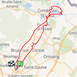

Length
32 km

Max alt
45 m

Uphill gradient
199 m
Km-Effort
35 km

Min alt
12 m

Downhill gradient
199 m
Boucle
Yes
Creation date :
2019-05-07 03:04:25.465
Updated on :
2019-05-07 03:04:25.465
--
Difficulty : Unknown

FREE GPS app for hiking
 SityTrail
IGN / Geographical institutes
SityTrail Plus
The world is yours!
About
Trail Other activity of 32 km to be discovered at Hauts-de-France, Nord, Valenciennes. This trail is proposed by dehemjacques.
Positioning
Country:
France
Region :
Hauts-de-France
Department/Province :
Nord
Municipality :
Valenciennes
Location:
Unknown
Start:(Dec)
Start:(UTM)
536730 ; 5579641 (31U) N.
Comments