


flavigny

ZAMBAUX
User
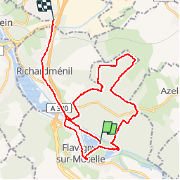

Length
19.4 km

Max alt
337 m

Uphill gradient
278 m
Km-Effort
23 km

Min alt
222 m

Downhill gradient
263 m
Boucle
No
Creation date :
2019-05-07 03:18:06.842
Updated on :
2019-05-07 03:18:06.842
3h12
Difficulty : Unknown

FREE GPS app for hiking
 SityTrail
IGN / Geographical institutes
SityTrail Plus
The world is yours!
About
Trail Walking of 19.4 km to be discovered at Grand Est, Meurthe-et-Moselle, Flavigny-sur-Moselle. This trail is proposed by ZAMBAUX.
Description
marche
Positioning
Country:
France
Region :
Grand Est
Department/Province :
Meurthe-et-Moselle
Municipality :
Flavigny-sur-Moselle
Location:
Unknown
Start:(Dec)
Start:(UTM)
293240 ; 5383525 (32U) N.
Comments