


Vexin Chavençon

c.rendu
User
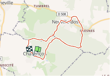

Length
7.7 km

Max alt
219 m

Uphill gradient
183 m
Km-Effort
10.1 km

Min alt
124 m

Downhill gradient
178 m
Boucle
Yes
Creation date :
2014-12-10 00:00:00.0
Updated on :
2014-12-10 00:00:00.0
--
Difficulty : Unknown

FREE GPS app for hiking
 SityTrail
IGN / Geographical institutes
SityTrail Plus
The world is yours!
About
Trail Other activity of 7.7 km to be discovered at Hauts-de-France, Oise, Chavençon. This trail is proposed by c.rendu.
Description
Essai de Editor
Positioning
Country:
France
Region :
Hauts-de-France
Department/Province :
Oise
Municipality :
Chavençon
Location:
Unknown
Start:(Dec)
Start:(UTM)
426683 ; 5448786 (31U) N.
Comments