


Zevtt - Naintré 2012

kipoura
User

Length
40 km

Max alt
155 m

Uphill gradient
495 m
Km-Effort
46 km

Min alt
60 m

Downhill gradient
494 m
Boucle
Yes
Creation date :
2019-05-03 17:10:43.903
Updated on :
2019-05-03 17:10:44.357
2h00
Difficulty : Easy

FREE GPS app for hiking
 SityTrail
IGN / Geographical institutes
SityTrail Plus
The world is yours!
About
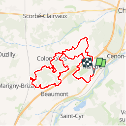
Trail Mountain bike of 40 km to be discovered at New Aquitaine, Vienne, Naintré. This trail is proposed by kipoura.
Description
Un parcours VTT aux 2 tiers roulant et le tiers restant ludique dans les bois de Colombiers .... http:zevtt.free.fr
Positioning
Country:
France
Region :
New Aquitaine
Department/Province :
Vienne
Municipality :
Naintré
Location:
Unknown
Start:(Dec)
Start:(UTM)
307904 ; 5181251 (31T) N.
Comments