


20120508 Orgelet

alexbnmr
User
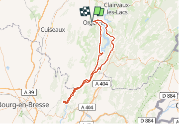

Length
111 km

Max alt
708 m

Uphill gradient
1913 m
Km-Effort
137 km

Min alt
269 m

Downhill gradient
1913 m
Boucle
Yes
Creation date :
2014-12-10 00:00:00.0
Updated on :
2014-12-10 00:00:00.0
--
Difficulty : Difficult

FREE GPS app for hiking
 SityTrail
IGN / Geographical institutes
SityTrail Plus
The world is yours!
About
Trail Cycle of 111 km to be discovered at Bourgogne-Franche-Comté, Jura, Orgelet. This trail is proposed by alexbnmr.
Description
Vouglans et vallee de l'Ain


Positioning
Country:
France
Region :
Bourgogne-Franche-Comté
Department/Province :
Jura
Municipality :
Orgelet
Location:
Unknown
Start:(Dec)
Start:(UTM)
699968 ; 5155340 (31T) N.
Comments