Trail Motor Châbons - Châbons-Bourgoin-Offroad - Photo

Châbons-Bourgoin-Offroad

 htonin
htonin

User

© OpenStreetMap contributors
Length
Length
38 km
Max alt
Max alt
691 m
Uphill gradient
Uphill gradient
619 m
Km-Effort
Km-Effort  
47 km
Min alt
Min alt
242 m
Downhill gradient
Downhill gradient
886 m
Boucle
Boucle
No
Creation date :
2014-12-10 00:00:00.0
Updated on :
2014-12-10 00:00:00.0

(1 Reviews)

Motor
Motor
1h30
Difficulty : Medium

Scan this QR Code to open this trail in the SityTrail application

FREE GPS app for hiking

Logo SityTrail SityTrail

IGN / Geographical institutes

Download SityTrail from the App Store Download SityTrail from Google Play

Logo SityTrail SityTrail World

The world is yours!

Download SityTrail from the App Store Download SityTrail from Google Play Download SityTrail on Huawei AppGallery

About

Trail Motor of 38 km to be discovered at Auvergne-Rhône-Alpes, Isère, Châbons. This trail is proposed by htonin.

Elevation profile

Positioning

Country:
France
Region :
Auvergne-Rhône-Alpes
Department/Province :
Isère
Municipality :
Châbons
Location:
Unknown
Start:(UTM)
689695 ; 5035007 (31T) N.

Comments

Please log in to post a review or rate the element


parcours sympa, simple au départ avec des passages très étroits (danger de multiples rayures pour ceux qui craignent ça mais ce n'était pas notre cas) patrol y60 et l200.1h30 tranquille pour arriver à mi parcours mais nous avons du nous interrompre là. à refaire au complet cette fois où reprendre là où on s'est arrêté. merci pour ce guide !


Trails nearby

Trail Walking Bévenais - téléthon Bévenais - Photo
Walking
lilloue

Walking

Difficult
(1)
Bévenais, Auvergne-Rhône-Alpes, Isère, France
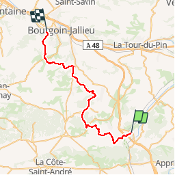
12 km | 17.6 km-effort
4h 9min
Yes
Trail Walking Oyeu - blaune 2023 - Photo
Walking
goizet

Walking

Easy
Oyeu, Auvergne-Rhône-Alpes, Isère, France
7.9 km | 10.9 km-effort
2h 50min
Yes
Trail Walking Bévenais - RD-Le-Grand-Lemps-Bevenais - Photo
Walking
raymondfn

Walking

Medium
(1)
Bévenais, Auvergne-Rhône-Alpes, Isère, France
8.6 km | 10.4 km-effort
2h 22min
Yes
Trail Walking Burcin - Dauphignac - Jour 1  (départ ND de Milin) - Photo
Walking
bertrand.gillet

Walking

Very difficult
(1)
Burcin, Auvergne-Rhône-Alpes, Isère, France
22 km | 29 km-effort
6h 7min
No
Trail Mountain bike Villages du Lac de Paladru - cirkwi circuit_vtt_n_22_ _coeurs_de_villages - Photo
Mountain bike
psomelet

Mountain bike

Very easy
Villages du Lac de Paladru, Auvergne-Rhône-Alpes, Isère, France
13.1 km | 16.2 km-effort
Unknown
Yes
Trail Mountain bike Villages du Lac de Paladru - cirkwi circuit_vtt_n_20_ _balade_initiatique - Photo
Mountain bike
psomelet

Mountain bike

Very easy
Villages du Lac de Paladru, Auvergne-Rhône-Alpes, Isère, France
5.1 km | 6.5 km-effort
Unknown
Yes
Trail Running Bizonnes - 9km - Photo
Running
mariustan

Running

Very easy
Bizonnes, Auvergne-Rhône-Alpes, Isère, France
9 km | 10.7 km-effort
1h 0min
No
Trail Walking Oyeu - Mont Saint Marc - Photo
Walking
raymondfn

Walking

Easy
Oyeu, Auvergne-Rhône-Alpes, Isère, France
10 km | 13.1 km-effort
3h 0min
Yes
Trail Walking Oyeu - silve bénite - Photo
Walking
SuperGillou

Walking

Medium
Oyeu, Auvergne-Rhône-Alpes, Isère, France
9.8 km | 13.8 km-effort
2h 37min
Yes


Close
My subscriptions