


CHEMIN DU SOLEIL

DANCHAUD
User
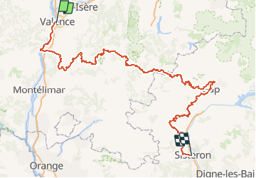

Length
351 km

Max alt
1815 m

Uphill gradient
10944 m
Km-Effort
495 km

Min alt
87 m

Downhill gradient
10569 m
Boucle
No
Creation date :
2014-12-10 00:00:00.0
Updated on :
2014-12-10 00:00:00.0
--
Difficulty : Medium

FREE GPS app for hiking
 SityTrail
IGN / Geographical institutes
SityTrail Plus
The world is yours!
About
Trail Mountain bike of 351 km to be discovered at Auvergne-Rhône-Alpes, Drôme, Valence. This trail is proposed by DANCHAUD.
Positioning
Country:
France
Region :
Auvergne-Rhône-Alpes
Department/Province :
Drôme
Municipality :
Valence
Location:
Unknown
Start:(Dec)
Start:(UTM)
649392 ; 4976723 (31T) N.
Comments