


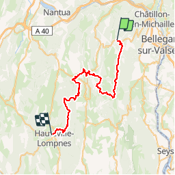
7 COL de CUVERY / HAUTEVILLE

DANCHAUD
User

Length
42 km

Max alt
1351 m

Uphill gradient
884 m
Km-Effort
55 km

Min alt
796 m

Downhill gradient
1261 m
Boucle
No
Creation date :
2014-12-10 00:00:00.0
Updated on :
2014-12-10 00:00:00.0
--
Difficulty : Medium

FREE GPS app for hiking
 SityTrail
IGN / Geographical institutes
SityTrail Plus
The world is yours!
About
Trail Mountain bike of 42 km to be discovered at Auvergne-Rhône-Alpes, Ain, Valserhône. This trail is proposed by DANCHAUD.
Description
7 eme ETAPE DE LA GTJ
Positioning
Country:
France
Region :
Auvergne-Rhône-Alpes
Department/Province :
Ain
Municipality :
Valserhône
Location:
Châtillon-en-Michaille
Start:(Dec)
Start:(UTM)
710826 ; 5110289 (31T) N.
Comments