


COUDES OLLOIX CHAMPEIX

DANCHAUD
User
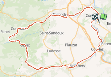

Length
55 km

Max alt
871 m

Uphill gradient
983 m
Km-Effort
68 km

Min alt
335 m

Downhill gradient
984 m
Boucle
Yes
Creation date :
2014-12-10 00:00:00.0
Updated on :
2014-12-10 00:00:00.0
--
Difficulty : Medium

FREE GPS app for hiking
 SityTrail
IGN / Geographical institutes
SityTrail Plus
The world is yours!
About
Trail Mountain bike of 55 km to be discovered at Auvergne-Rhône-Alpes, Puy-de-Dôme, Vic-le-Comte. This trail is proposed by DANCHAUD.


Positioning
Country:
France
Region :
Auvergne-Rhône-Alpes
Department/Province :
Puy-de-Dôme
Municipality :
Vic-le-Comte
Location:
Unknown
Start:(Dec)
Start:(UTM)
516608 ; 5055727 (31T) N.
Comments