


21 AVRIL 2012

DANCHAUD
User

Length
39 km

Max alt
689 m

Uphill gradient
730 m
Km-Effort
49 km

Min alt
325 m

Downhill gradient
729 m
Boucle
Yes
Creation date :
2014-12-10 00:00:00.0
Updated on :
2014-12-10 00:00:00.0
--
Difficulty : Medium

FREE GPS app for hiking
 SityTrail
IGN / Geographical institutes
SityTrail Plus
The world is yours!
About
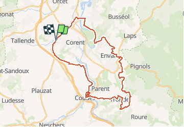
Trail Mountain bike of 39 km to be discovered at Auvergne-Rhône-Alpes, Puy-de-Dôme, Veyre-Monton. This trail is proposed by DANCHAUD.
Positioning
Country:
France
Region :
Auvergne-Rhône-Alpes
Department/Province :
Puy-de-Dôme
Municipality :
Veyre-Monton
Location:
Unknown
Start:(Dec)
Start:(UTM)
513227 ; 5057254 (31T) N.
Comments